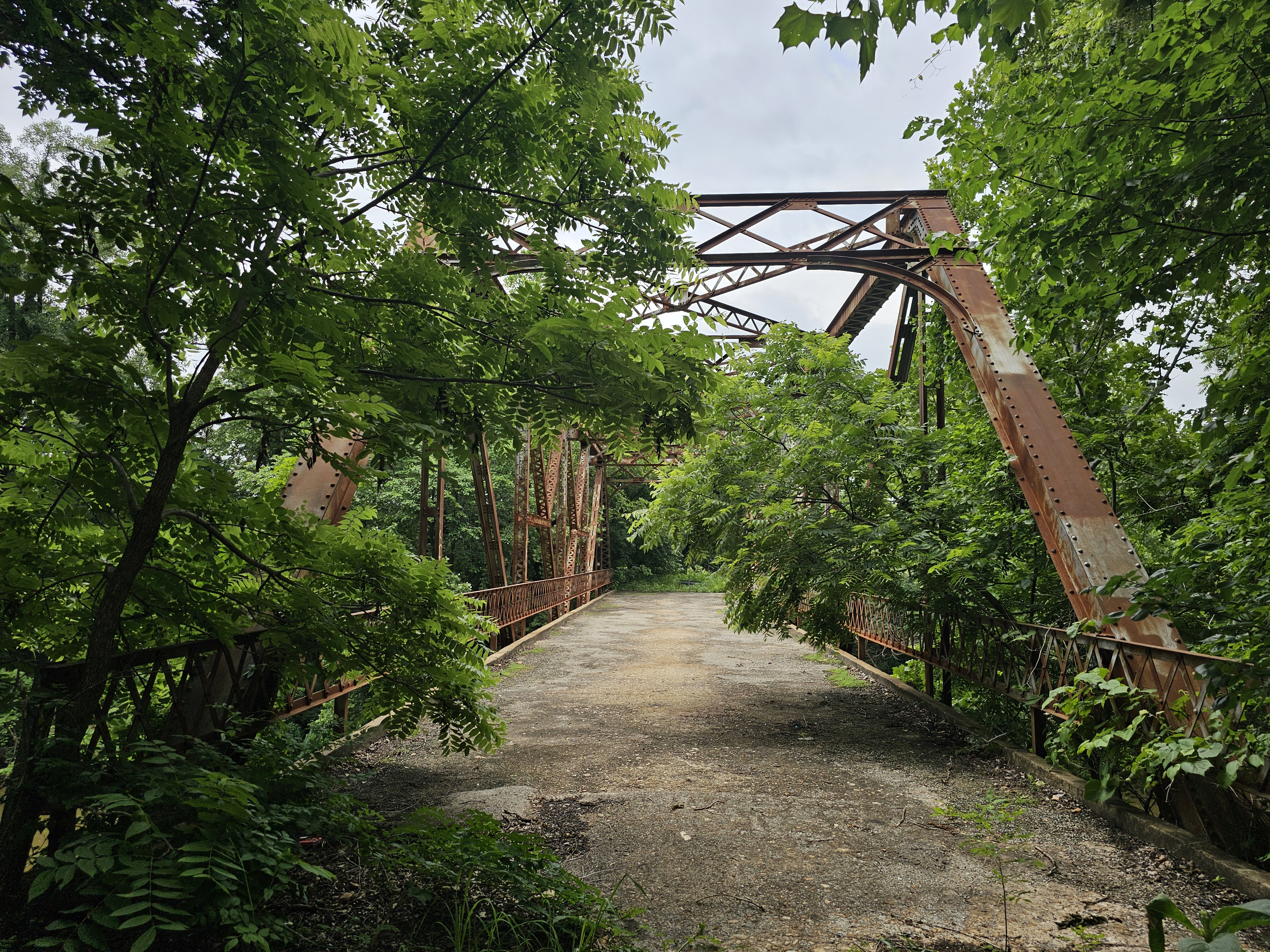
Bridge #76
Built 1930 (96 yrs ago)
Closed to traffic
Through Truss
Bridge #76
Through Truss
Built 1930
Built
1930
Type
Through Truss
Style
Pratt
Visits
1
Identity & location
- NBI Number
- 031690000000000
- Structure Number
- 57N3850E0200004
- Carries
- CR 2732
- Crosses
- Sand Creek
- Year Built
- 1930
Structure
Pratt Through Truss
- Bridge Type
- Through Truss
- Main Span Style
- Pratt
Photos · 18
Unattached photos
Visit log · 1
-
Jun 1, 2024by Mike Roquemore
Appears in datasets
ODOT Off System Bridges NBI
Survey data vs. current bridge record
| Field | Survey | Bridge | |
|---|---|---|---|
| NBI No | 03169 | 03169 | ✓ |
| Structure No | 57N3850E0200004 | 57N3850E0200004 | ✓ |
| ODOT BRKEY | 3169 | — | ⚠ |
| County | Osage | Osage | ✓ |
| Facility Carried | IRR 5768C | CR 2732 | ✗ |
| Feature | SAND CREEK | Sand Creek | ✓ |
| Alt Name | 57N3852E0200004 | — | ⚠ |
| Description | 122ft. HI. TRUSS SPAN | — | ⚠ |
| Year Built | 1930 | 1930 | ✓ |
| Latitude | 36.71977222 | 36.7196389 | ✗ |
| Longitude | -96.13248889 | -96.1325000 | ✗ |
| Overall Length | 122.047 | — | ⚠ |
| Deck Width | 20.669 | — | ⚠ |
| Main Spans | 1 | — | ⚠ |
| Skew | 0 | — | ⚠ |
| Lanes | 2 | — | ⚠ |
| Road Width | 16.732 | — | ⚠ |
| Material | 3 - Steel | — | ⚠ |
| Design | Truss — Thru (10) | — | ⚠ |
| Span Type Main | Main span (M) | — | ⚠ |
| Deck Structure | Concrete cast-in-place (1) | — | ⚠ |
| Open / Closed | Closed (K) | — | ⚠ |
| Sufficiency | 9 | — | ⚠ |
| Structure Rating | Failed (0) | — | ⚠ |
| Deck Rating | Failed (0) | — | ⚠ |
| Super Rating | Failed (0) | — | ⚠ |
| Sub Rating | Failed (0) | — | ⚠ |
| Culvert Rating | Not applicable (N) | — | ⚠ |
| Owner | 02 - County Highway Agency | — | ⚠ |
| Custodian | 02 - County Highway Agency | — | ⚠ |
| Hwy System | 0 - Off Highway | — | ⚠ |
| Functional Class | 07 - Major Collector (Rural) | — | ⚠ |
| Bridge System | D | — | ⚠ |
| ADT | 500 | — | ⚠ |
| ADT Year | 2012 | — | ⚠ |
| Historical | 4 | — | ⚠ |
Source: Oklahoma Department of Transportation (ArcGIS / NBI) · Imported May 6, 2026
Oklahoma Spans of Time 2007
Survey data vs. current bridge record
| Field | Survey | Bridge | |
|---|---|---|---|
| County | Osage | Osage | ✓ |
| Structure No | 57N3850E0200004 | 57N3850E0200004 | ✓ |
| Build Date | 1930 | 1930 | ✓ |
| Bridge Type | Through Truss | Through Truss | ✓ |
| Num Spans | 1 | — | ⚠ |
| Total Length | 122 | — | ⚠ |
| Longest Span | 122 | — | ⚠ |
| Builder Plate | No | — | ⚠ |
| Connections | riveted | — | ⚠ |
| Builder | — | ⚠ | |
| Curb Width | 17 | — | ⚠ |
| NR Eligible | No | — | ⚠ |
Source: Oklahoma Department of Transportation · Imported May 4, 2026
Oklahoma Spans of Time 1993
Survey data vs. current bridge record
| Field | Survey | Bridge | |
|---|---|---|---|
| County | Osage | Osage | ✓ |
| Structure Number | 57N3850E0200004 | 57N3850E0200004 | ✓ |
| Built Year | 1930 | 1930 | ✓ |
| Bridge Type | Through Truss | Through Truss | ✓ |
| Bridge Design | Modified Pratt | — | ⚠ |
| Num Spans | 1 | — | ⚠ |
| Total Length | 122 | — | ⚠ |
| Main Span Length | 122 | — | ⚠ |
| Builder Plate | No | — | ⚠ |
| Connections | riveted | — | ⚠ |
| Curb Width | 17 | — | ⚠ |
| NRHP Listed | No | ✓ |
Source: Oklahoma Department of Transportation / Spans of Time (1993) · Imported May 6, 2026
All surveys vs. bridge record
3 surveys · 45 fields
| Field | Bridge | 2026 | 2007 | 1993 |
|---|---|---|---|---|
| NBI No | 03169 | 03169 ✓ | — | — |
| Structure No | 57N3850E0200004 | 57N3850E0200004 ✓ | 57N3850E0200004 ✓ | 57N3850E0200004 ✓ |
| ODOT BRKEY | — | 3169 | — | — |
| County | Osage | Osage ✓ | Osage ✓ | Osage ✓ |
| Facility Carried | CR 2732 | IRR 5768C ✗ | — | — |
| Feature | Sand Creek | SAND CREEK ✓ | — | — |
| Alt Name | — | 57N3852E0200004 | — | — |
| Description | — | 122ft. HI. TRUSS SPAN | — | — |
| Year Built | 1930 | 1930 ✓ | 1930 ✓ | 1930 ✓ |
| Latitude | 36.7196389 | 36.71977222 ✗ | — | — |
| Longitude | -96.1325000 | -96.13248889 ✗ | — | — |
| Overall Length | — | 122.047 | — | — |
| Deck Width | — | 20.669 | — | — |
| Main Spans | — | 1 | — | — |
| Skew | — | 0 | — | — |
| Lanes | — | 2 | — | — |
| Roadway / Curb Width | — | 16.732 | 17 | 17 |
| Material | — | 3 - Steel | — | — |
| Design | — | Truss — Thru (10) | — | — |
| Span Type Main | — | Main span (M) | — | — |
| Deck Structure | — | Concrete cast-in-place (1) | — | — |
| Open / Closed | — | Closed (K) | — | — |
| Sufficiency | — | 9 | — | — |
| Structure Rating | — | Failed (0) | — | — |
| Deck Rating | — | Failed (0) | — | — |
| Super Rating | — | Failed (0) | — | — |
| Sub Rating | — | Failed (0) | — | — |
| Culvert Rating | — | Not applicable (N) | — | — |
| Owner | — | 02 - County Highway Agency | — | — |
| Custodian | — | 02 - County Highway Agency | — | — |
| Hwy System | — | 0 - Off Highway | — | — |
| Functional Class | — | 07 - Major Collector (Rural) | — | — |
| Bridge System | — | D | — | — |
| ADT | — | 500 | — | — |
| ADT Year | — | 2012 | — | — |
| Historical | — | 4 | — | — |
| Bridge Type | Through Truss | — | Through Truss ✓ | Through Truss ✓ |
| Num Spans | — | — | 1 | 1 |
| Total Length | — | — | 122 | 122 |
| Main / Longest Span | — | — | 122 | 122 |
| Builder Plate | — | — | No | No |
| Connections | — | — | riveted | riveted |
| NR Eligible | — | — | No | — |
| Bridge Design | — | — | — | Modified Pratt |
| NRHP Listed | — | — | No ✓ |
✓ matches the bridge record · ✗ differs · blank in the Bridge column means the bridge record has no value for that field.
Comments · 0
Log in to leave a comment.
No comments yet. Be the first to comment.
See something wrong?
If you notice an error in the information above, submit a correction and we'll review it.